393 insights gathered from the community
We know there is a lot of interest in the future planning of this site.
While we welcome all suggestions, any future plans will depend on the findings of the Preliminary Feasibility Study (the Planning Report, Building Consultancy Report and Environmental Advice, available in the Document library) we wanted to hear your ideas, suggestions and aspirations so they can help us shape the next steps.
We asked for:
- Your Connection: How do you currently use the space at the Site? Do you visit, run a business, socialise, or live nearby?
- Your Vision: Considering the Site's history and limitations, what do you think would be a good use for this space?
- Partnership Opportunities: Council would like to explore options for partnerships and/or revenue-generating uses to support the long-term viability of the Site. Do you have any suggestions/ideas for how we could achieve this?
Check the Community & Stakeholder Engagement findings below.
Community & Stakeholder Engagement Summary
Thank you to everyone who provided feedback and participated in Stage 1 Community & Stakeholder Engagement. This consultation sought to better understand local residents' vision for the site. Please see the engagement summary below or view the Community & Stakeholder Engagement report, available in the Document library.
-
-
4 engagement tools (online survey, Pop Ups, Q&A sessions and stakeholder interviews)
-
1 dedicated workshop with Wurundjeri Woi-wurrung Cultural Heritage Aboriginal Corporation
Key opportunities identified by community and stakeholders include:
- creation of a nationally-recognised hub for urban food production,
- education and circular economy enterprises,
- adaptive reuse of existing buildings to provide affordable spaces for social enterprises, artists, and local organisations, and
- stronger ecological and transport connections to Darebin Parklands and Alphington Station.
The following concerns were raised by community members and stakeholders:
- loss of public ownership,
- environmental contamination,
- amenity and traffic impacts,
- a perception that financial drivers might outweigh community benefit, and
- Governance transparency
The following key considerations respond directly to community and stakeholder feedback and should be assessed in light of Council’s strategic priorities, budgetary and resource considerations as well as the needs of the greater Darebin community.
- Retain public ownership,
- Adopt a transparent and collaborative governance model,
- Environmental remediation and regeneration,
- Enhancement of existing uses,
- Embed Wurundjeri leadership and cultural expression,
- Prioritise connectivity and access, and
- Develop a long-term implementation and funding strategy
Site Location
The Subject Site is approximately 3.5 hectares in size and is located at 2 Wingrove Street, Alphington - opposite the Alphington train station. It is bordered by the Darebin Parklands and the Hurstbridge train line. The property is easily accessible via the main gate on Wingrove Street.
Site background
From the early 1900s to 2023, the Site has been utilised as:
- Bluestone quarry
- Alphington tip (landfill)
- Northcote City Council works depot
- Darebin Enterprise Centre Ltd - business incubator site (through a lease from Council)
The previous uses of the site have resulted in there being many site-specific considerations which must be taken into account when determining any potential future use of the property. To determine the suitability of the site to deliver potential uses, Council has been actively undertaking various site investigations listed below:
- Building conditions
- Soil and groundwater contamination
- Continual subsidence
- Planning controls
A Site Masterplan needs to be done to identify viable uses - taking into account of the site-specific considerations, market appetite, financial implications and community needs now and in the future.
Council is currently in the process of undertaking the first stage of the Site Masterplan, which includes:
- a preliminary feasibility study detailing the site-specific considerations, constraints and opportunities
- collecting feedback and input from the community through the first round of community consultation
- establishing a Community Reference Group (CRG) to provide a structured, transparent, diverse and inclusive medium for community representation throughout the masterplanning process
- preparing an Expression of Interest (EOI) process to identify parties (community and/or commercial organisations) that would like to partner with Council to develop and implement the masterplan.
Site limitations
The ‘preliminary feasibility study’ has been undertaken by Council to determine site conditions, limitations, and constraints. These key feasibility reports, the Planning Report - future use of 2 Wingrove Street, Alphington, Building Consultancy Report and Environmental Advice can be viewed and accessed in the document library.
Also refer to the summary of key findings listed below:
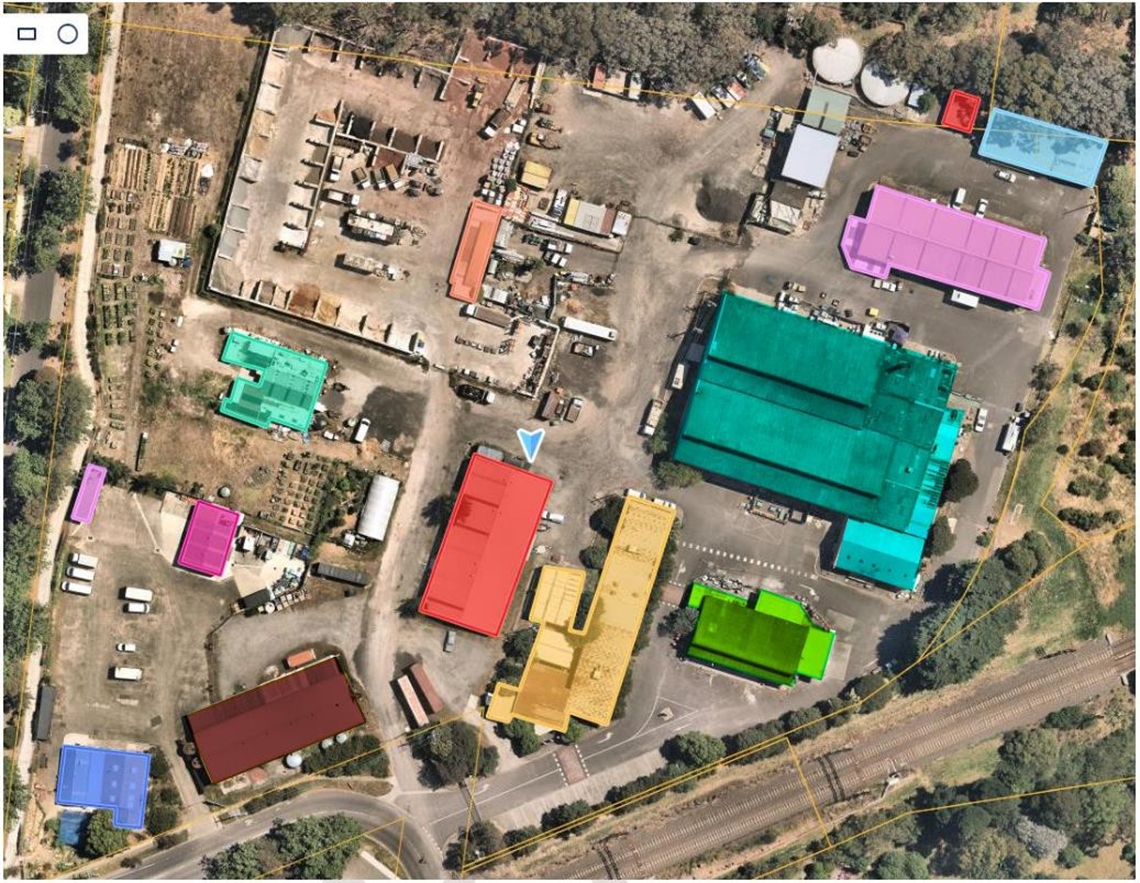
- Building conditions
Half of the buildings on site are at the end of their useful life – this means it would not make sense to bring them back up to usable standard.
Four buildings are mostly not in good condition and/or only suitable for a few uses. There are constraints about how many different purposes they could be put to.
- Soil history and constraints
The site comprises of 3.5 hectares and was used as a bluestone quarry from 1890 to 1976, and a landfill (with an approximate area of 2 hectares) until 1975. The extent of the waste mass across the site, depth of buried waste beneath the site and the cap condition – are generally unknown. The site contains unknown waste types including industrial and liquid waste. This means that sensitive uses are not possible on it – for example it cannot be used for housing. In addition, subsidence has been observed on site – this means that not all the of the site is stable enough to build on.
- Planning advice
The site is zoned as Public Use Zone (PUZ). The zoning enables some commercial use – on the basis it is ‘ancillary’ to a public use but usually needs a planning permit to confirm approval. The site is also subject to Environmental Significance Overlay (ES02) which seeks to protect the Darebin Creek and environs by ensuring that any future use considers potential environmental impacts to the creek.


